Maps — The coastal town of Seabridge in 1990 and today
📄 Bài mẫu band 8–9
| Introduction | Paraphrase: hai bản đồ cho thấy thị trấn ven biển Seabridge năm 1990 và hiện nay. |
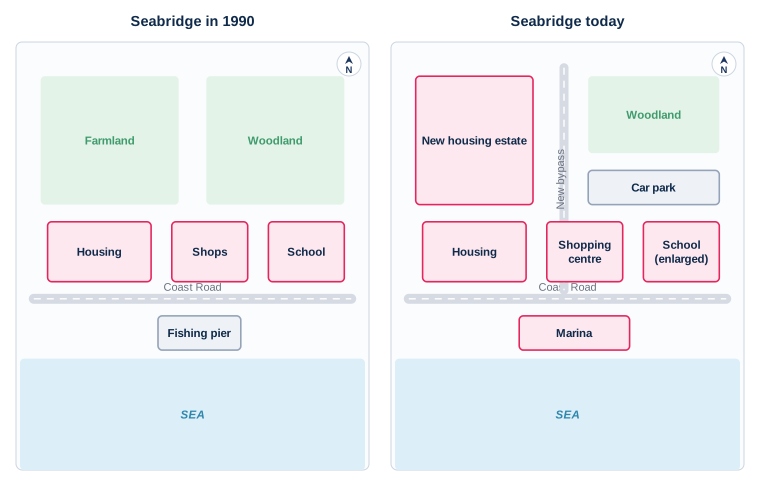
| Overview | Overall: Seabridge chuyển từ thị trấn nông nghiệp – đánh cá sang thị trấn dân cư và du lịch; hai mốc giữ nguyên là Coast Road và khu nhà ở phía tây. |
| Body 1 | Phía bắc Coast Road: đồng ruộng biến mất, thay bằng khu nhà ở mới; rừng cây bị thu nhỏ để nhường chỗ cho bãi đỗ xe; một tuyến tránh mới chạy bắc–nam nối vào Coast Road. |
| Body 2 | Phía nam và ven biển: cầu cảng cá bị thay bằng bến du thuyền lớn hơn; dãy cửa hàng thành trung tâm mua sắm; trường học được mở rộng. |
The two maps show the coastal town of Seabridge as it was in 1990 and as it is today.
Overall, Seabridge has been transformed from a farming and fishing settlement into a residential and leisure town. The Coast Road and the housing at the western end are the only features to survive unchanged, while almost everything to the north of the road has been rebuilt.
The greatest changes have taken place north of the Coast Road. The farmland that once occupied the north-western corner has been built over with a large new housing estate, and the woodland to its east has been reduced in size to make room for a car park. A new bypass now runs from north to south between the two, joining the Coast Road at the centre of the town.
Along the road itself, the row of shops has been replaced by a single shopping centre, and the school immediately to the east has been enlarged. On the seafront, the fishing pier has been demolished and a marina, noticeably wider, has been built in its place.
| residential and leisure town | thị trấn dân cư và nghỉ dưỡng |
| the only features to survive unchanged | những công trình duy nhất còn nguyên |
| north of the Coast Road | phía bắc đường Coast Road |
| built over | bị xây đè lên |
| reduced in size | bị thu nhỏ lại |
| from north to south | theo hướng bắc – nam |
| immediately to the east | ngay về phía đông |
| On the seafront | Trên mặt tiền biển |
| in its place | thay vào chỗ đó |