Maps — An archaeological site in 2004 and 2014
📄 Bài mẫu band 8–9
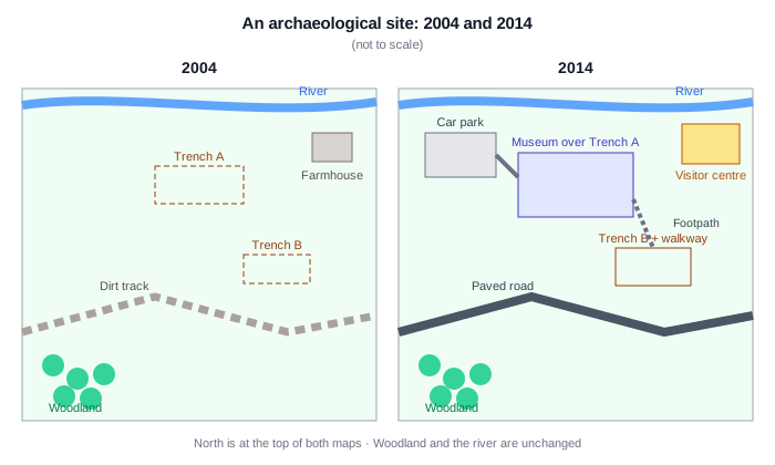
| Introduction | Paraphrase: hai bản đồ một khu khảo cổ năm 2004 và 2014 sau khi được đầu tư đón khách. |
| Overview | Overall: từ điểm đào bới thuần nghiên cứu, khu đất thành điểm tham quan — bảo tàng xây trùm lên hố A, thêm nhà đón khách, bãi xe, đường nhựa; sông và rừng phía nam giữ nguyên. |
| Body 1 | 2004: sông chảy ngang phía bắc; hai hố khai quật A (giữa khu) và B (đông nam) chỉ là hố lộ thiên; một nhà nông trại nhỏ; đường đất chạy ngang phía nam; rừng góc tây nam. |
| Body 2 | 2014: bảo tàng dựng ngay trên hố A để khách xem hiện vật tại chỗ; hố B thêm lối đi lát ván; nhà nông trại thay bằng trung tâm đón khách góc đông bắc; thêm bãi xe phía tây, đường đất nâng thành đường nhựa, lối bộ hành nối các điểm. |
The two maps show an archaeological site as it was in 2004 and the same site in 2014, by which time it had been opened up to visitors.
Overall, a working excavation with almost no facilities was transformed into a visitor attraction: a museum was built directly over the main trench, a visitor centre and car park were added, and the rough track across the site was upgraded to a proper road. The river and the woodland, meanwhile, survived intact.
In 2004 the site was defined by its natural features and its digs. A river ran along the northern edge, with a small farmhouse standing to its south-east. Two excavation trenches lay open to the elements — Trench A near the centre of the site and the smaller Trench B in the south-east — and the only access was a dirt track winding across the southern half, with a patch of woodland in the south-west corner.
By 2014 the site had been thoroughly redeveloped. A museum had been constructed directly on top of Trench A, allowing visitors to view the remains where they were found, while Trench B had gained a raised walkway. The farmhouse had made way for a visitor centre in the north-east, a car park had been laid out in the west, and the old track had become a paved road, linked to the buildings by footpaths. Only the river and the woodland were left untouched.
| opened up to visitors | mở cửa đón khách |
| built directly over | xây trùm ngay lên |
| survived intact | còn nguyên vẹn |
| excavation trenches | hố khai quật |
| dirt track | đường đất |
| directly on top of | ngay bên trên |
| made way for | nhường chỗ cho |
| paved road | đường trải nhựa |
| left untouched | được giữ nguyên |