Maps — The town of Willington in 1780, 1860 and 2000 (three maps)
📄 Bài mẫu band 8–9
| Introduction | Paraphrase: ba bản đồ thị trấn Willington ở ba mốc 1780, 1860 và 2000. |
| Overview | Overall: thị trấn đi qua ba thời đại — làng nông nghiệp nhỏ bên sông (1780), thị trấn công nghiệp có đường sắt (1860), rồi đô thị dịch vụ ngoại ô (2000); dòng sông và vị trí cối xay là hai hằng số. |
| Body 1 | 1780 + 1860: làng 12 nóc nhà, nhà thờ, ruộng, cối xay nước, lội sông qua bãi cạn → 1860 nhà máy sợi chạy hơi nước, dãy nhà công nhân, đường sắt + ga, cầu đá thay bãi cạn; cối xay vẫn còn. |
| Body 2 | 2000: nhà máy biến mất — thay bằng trung tâm mua sắm và khu văn phòng; đường sắt thành đường bộ chính; cầu mở rộng; cối xay cũ thành bảo tàng; công viên ven sông mới; nhà ở ngoại ô phủ quanh. |
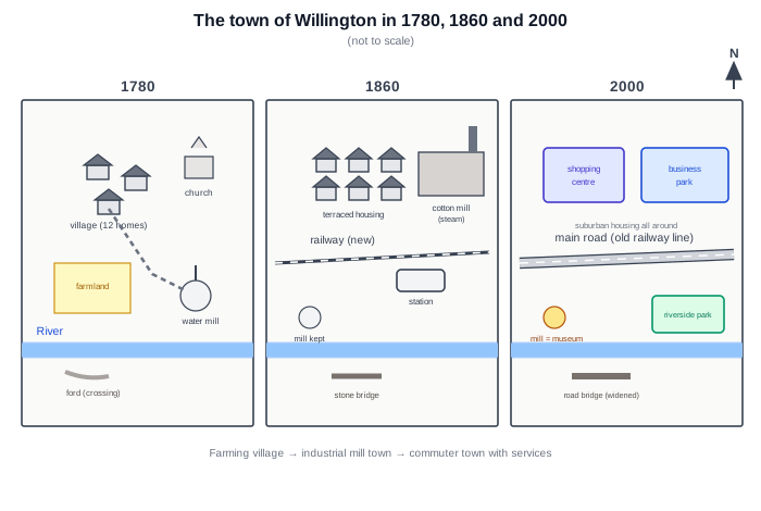
The three maps show how the town of Willington developed over 220 years, in 1780, 1860 and 2000.
Overall, the town passed through three distinct eras — a small farming village, then a railway-age mill town, and finally a modern service centre — while the river and the old water mill site remained fixed points throughout.
In 1780 Willington was tiny: a village of about twelve homes with a church, an area of farmland, and a water mill beside the river, which people crossed at a simple ford. By 1860 industry had transformed the town. A steam-powered cotton mill had been built, rows of terraced housing had replaced the scattered cottages, and a railway with its own station cut across the town, while a stone bridge replaced the ford. Notably, the old mill still stood.
By 2000 the industry had gone in its turn. The cotton mill had disappeared, and a shopping centre and business park occupied the northern side of town, surrounded by suburban housing. The railway line had been converted into the main road, the bridge had been widened for cars, and a riverside park had been laid out. The one survivor of 1780 was the water mill — preserved as a museum.
| three distinct eras | ba thời đại rõ rệt |
| water mill site | vị trí cối xay nước |
| water mill | cối xay nước |
| ford | bãi cạn lội qua sông |
| cotton mill | nhà máy sợi |
| terraced housing | dãy nhà liền kề |
| stone bridge | cầu đá |
| shopping centre and business park | trung tâm mua sắm và khu văn phòng |
| main road | đường chính |
| preserved as a museum | được giữ làm bảo tàng |