Map — A city in 1950 and at the present day
📄 Bài mẫu band 8–9
| Introduction | Paraphrase: hai bản đồ so sánh một thành phố năm 1950 và hiện nay. |
| Overview | Overall: thành phố đã được cải tạo toàn diện, chuyển từ chức năng cảng - chợ truyền thống sang đô thị mua sắm và du lịch; chỉ dòng sông và trục phố chính còn giữ nguyên. |
| Body 1 | Thay thế: chợ trung tâm → trung tâm thương mại; dãy nhà thấp → chung cư cao tầng; bến cảng ven sông → bến du thuyền và khách sạn. |
| Body 2 | Thêm mới: đường vành đai chạy từ bắc xuống Main Street, bãi đỗ xe, công viên công cộng thay cho đất nông nghiệp; Main Street được biến thành phố đi bộ. |
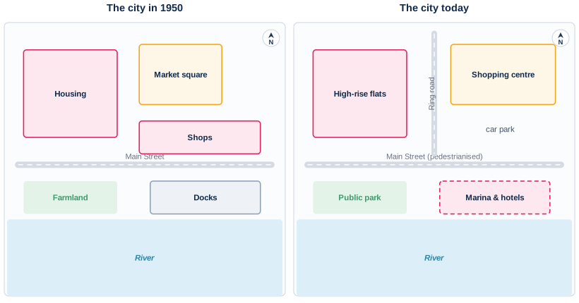
The two maps compare the layout of one city as it was in 1950 with its present-day arrangement.
Overall, the city has been extensively redeveloped, changing from a working port with a traditional market into a centre for shopping, leisure and tourism. Only the river and the line of Main Street remain unaltered.
Several of the original features have disappeared. The market square that occupied the north of the city gave way to a considerably larger shopping centre, which now extends further east. The row of small shops along Main Street has gone, and the low-rise housing in the north-west has been replaced by high-rise flats on the same site. Most strikingly, the docks on the northern bank of the river have been converted into a marina with hotels.
A number of facilities have also been added. A ring road now runs from the north of the city down to Main Street, and a car park has been built beside the shopping centre to serve it. The farmland that lay south of Main Street has made way for a public park. Main Street itself follows its original route but has been pedestrianised, so through traffic is now carried by the new ring road instead.
| remain unaltered | giữ nguyên không đổi |
| gave way to | nhường chỗ cho |
| has been replaced by | đã được thay thế bằng |
| have been converted into | đã được cải tạo thành |
| has made way for | đã nhường chỗ cho |
| has been pedestrianised | đã được biến thành phố đi bộ |